BayernInfo Maps 4.5.1
Free Version
Publisher Description


BayernInfo Maps - BAYERNINFO.MAPS: traffic information, Webcams, driving directions, parking, bus & train
BAYERNINFO MAPS offers "route planning for cars" and "travel information for bus & train" in one app - and all for free!
Surprises along the way are becoming rarer. Knowing construction sites, closures and delays in advance means less stress and lower travel costs. And if something unforeseen happens on the way, you always have alternative route recommendations at hand.
BAYERNINFO MAPS provides the most important information for planning your trip:
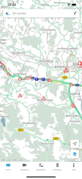
- Current traffic situation with all known construction sites, closures and traffic reports for all of Bavaria
- Images from around 500 traffic cameras along the motorways, federal and state roads in Bavaria and neighboring regions (due to current developments in Europe, the images from the traffic cameras are only available to a limited extent until further notice)
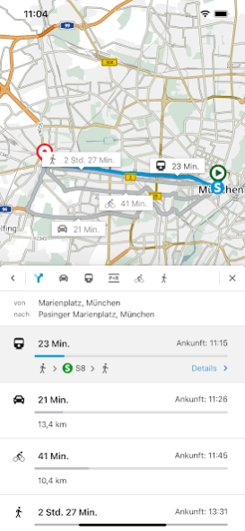
- Intermodal route planning for cars, buses and trains, on request also for Park & Ride, bicycles and pedestrians
- Stops and POIs - Current departure times and delays in public transport
- Construction site calendar for the phone version
- Route overview: current delay times on selected routes at a glance
Finally, a brief explanation of the purposes for which the app requires certain permissions:
- Precise location (GPS): Necessary to display your own position and for routing from / to your own location
- Full internet access: Required to access the server-side services (map, location and route search)
- Access to protected memory: Necessary for caching (intermediate storage) of map data
Services from the BayernInfo project were co-financed by the European Union.
BAYERNINFO MAPS - mobile information - relaxed on the way - arrive safely
About BayernInfo Maps
BayernInfo Maps is a free app for Android published in the Geography list of apps, part of Education.
The company that develops BayernInfo Maps is Bayerische Staatsregierung. The latest version released by its developer is 4.5.1.
To install BayernInfo Maps on your Android device, just click the green Continue To App button above to start the installation process. The app is listed on our website since 2023-08-15 and was downloaded 2 times. We have already checked if the download link is safe, however for your own protection we recommend that you scan the downloaded app with your antivirus. Your antivirus may detect the BayernInfo Maps as malware as malware if the download link to com.ptvag.vib.bayerninfo is broken.
How to install BayernInfo Maps on your Android device:
- Click on the Continue To App button on our website. This will redirect you to Google Play.
- Once the BayernInfo Maps is shown in the Google Play listing of your Android device, you can start its download and installation. Tap on the Install button located below the search bar and to the right of the app icon.
- A pop-up window with the permissions required by BayernInfo Maps will be shown. Click on Accept to continue the process.
- BayernInfo Maps will be downloaded onto your device, displaying a progress. Once the download completes, the installation will start and you'll get a notification after the installation is finished.
